Iowa Civil War Monuments
Cass County
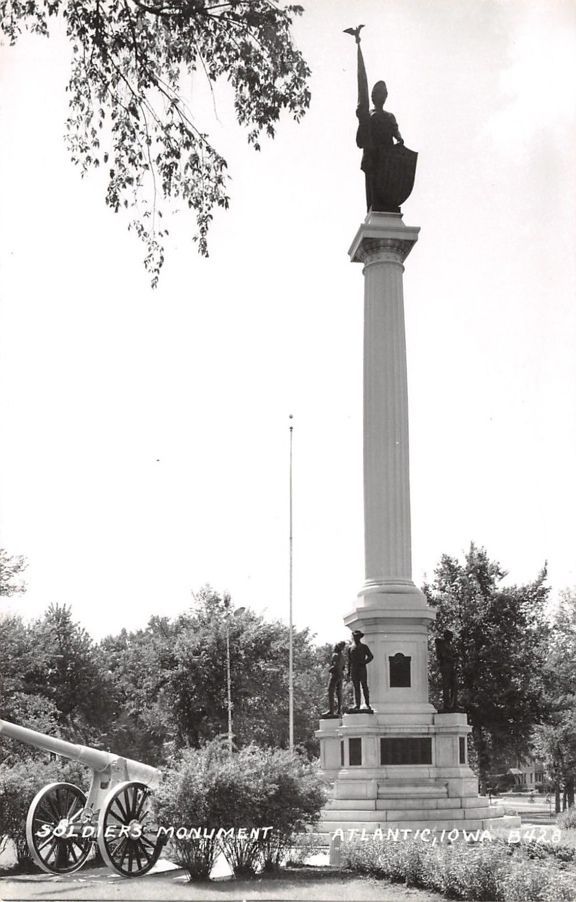
Atlantic - Cass County/Lady Liberty Monument - GPS Coordinates: 41.404516 by -95.013433
This is an impressive 62 foot monument with four bronze soldiers and sailors and bronze plaques listing Cass County veterans. Lady Liberty sets on top of the monument. The statues represent the infantry, artillery, Navy and WWI. There are bronze plaques on each side of the monument representing soldiers from the area. To commemorate restoration work, there was a re-dedication of the monument on 7/13/13 with a photo of members from the Kinsman and Kirkwood SUVCW Camps in Atlantic and Council Bluffs who conducted the ceremony. The original dedication was July 10, 1919 - the poster from that ceremony is shown. The monument commemorates veterans from the Civil War, Spanish-American War and WWI. There is also a more modern Veterans Monument. The location is in a park south of the business district and off Highway 6. Photos taken 7/13/13, 8/19/14 and 6/29/18. Also shown is an old photo, thanks to David Shedlock, with a cannon (non-Civil War) that is now missing.


Atlantic - GAR Flagpole - GPS Coordinates: 41.401983 by -94.983567
The GAR Flagpole in the Atlantic Cemetery was recently moved and restored with a new plaque and remounting of the original plaques for the GAR, Ladies of the GAR, and the WRC. This is a very nice area with about 20 headstones of Civil War Veterans near the flagpole. This is located on the western edge of the cemetery. The cemetery is located on the eastern entrance to town off Highways 6/71/83. SUVCW member Dave Hancock has done much of the work on this restoration project. Also, thanks to Dennis Sasse for notifying me of this monument. The first photo was taken 9/13/11 and the others 6/29/18.


Edna Township - Soldiers Monument in Reno Cemetery - GPS Coordinates: 41.200800 by -94.888733
This is an unusual little monument dedicated to soldiers in the Reno Cemetery in Cass County. It is located about 5 miles south of the town of Cumberland. Take County Road N28 - then turn west on G61/Victoria Road to the cemetery. The monument is to the right at the entrance by the old church bell. Thanks to Steve Hanken for the photo and notification of this monument.

Lewis - General Samuel Curtis Memorial Bridge - GPS Coordinates: 41.317224 by -95.086667
Highway 6 runs coast-to-coast and is named the Grand Army of the Republic Highway. The Iowa SUVCW has named 11 bridges on the Highway after Iowa CW Generals. There are also 29 GAR Highway markers across the state - an example is listed under Oakland in Pottawattamie County. This bridge is named after Samuel Curtis, an outstanding General from Keokuk. He was a Mayor of Keokuk and Congressman from Iowa before the War. He led the Army of the Southwest to victory at the Battle of Pea Ridge in 1862 and continued to direct military operations west of the Mississippi. There is a statue of him shown on this web site - see Keokuk in Lee County. This bridge is on Highway 6 just northwest of Lewis in Cass County. Photo taken 5/12/12.

Lewis - George B. Hitchcock House/Underground Railroad - GPS Coordinates: 41.303266 by -95.103483
This house was a station on the Underground Railroad. It was built of sandstone from a local quarry in 1856 and is now on the National Register of Historic Places. George Hitchcock was a Congregational minister and active in helping fugitive slaves to freedom. The house is located one mile west and 1/2 mile south of Lewis. It is off Nishna Valley Road which runs west out of Lewis. Call 712 769-2323 for information about tours. Photos taken 5/16/09 and 8/19/14.


Lewis - Monument for Iowa 23rd Infantry and Freedom Rock - GPS Coordinates: 41.304833 by -95.078583
Company I of the Iowa 23rd was mustered on this spot at the courtyard square at Lewis, the former county seat of Cass County. All 97 men in Company I were from Cass County. The Iowa 23rd was best known for their heroic action at Big Black River on May 17, 1863 in the Vicksburg Campaign. The SUVCW Kinsman Camp #23 presented the monument to the City of Lewis. The SUVCW dedication was September 27, 2008. The location, now known as East Park, is at Fifth and Court on the east side of town. Photos taken 9/27/08. On a subsequent visit it was noted that an impressive new Veterans memorial was constructed in the NE corner of the Park. This includes a "Freedom Rock" by artist Ray "Bubba" Sorensen - one side of the rock has a painting of the 23rd Iowa. This photo was taken 5/12/18.


